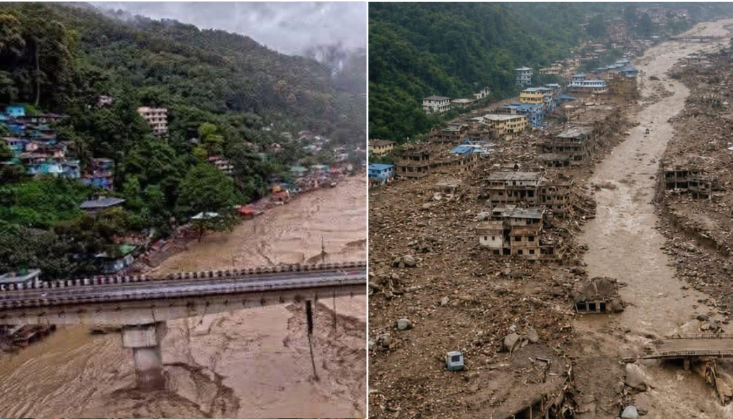
Yesterday’s catastrophic flash flood in Nepal’s Rasuwa district has once again demonstrated how quickly the Himalayas can turn from a landscape of beauty into a zone of unimaginable destruction. But for Sikkim, the images coming out of Nepal carry an uncomfortable familiarity.
In October 2023, Sikkim witnessed one of the region’s most devastating glacial disasters when South Lhonak Lake breached, triggering a Glacial Lake Outburst Flood (GLOF) that surged into the Teesta basin. The disaster destroyed the Teesta III hydropower project, bridges, roads and settlements, leaving dozens dead and many still missing.
Yesterday’s Nepal disaster was different in its immediate mechanism. Preliminary assessments indicate that a large section of a Himalayan glacier collapsed, sending ice, rock, sediment and water violently down the valley and producing a devastating flash flood. Satellite imagery and expert analysis have pointed towards glacier collapse rather than an earthquake as the primary trigger.
A catastrophic flood struck the Nepal-Tibet border on August 26, 2026, killing at least 165 people and leaving nearly 1,500 missing, including around 750 foreigners. The disaster was caused by the collapse of the lower part of a Himalayan glacier into the valley, producing a powerful flow of ice, rock, and debris that surged through the Lhende Khola River. This triggered high-speed flash floods that hit Gyirong port in Tibet and areas in Nepal, destroying roads, power infrastructure, and submerging villages. Authorities in Nepal identified numerous missing foreign nationals, including citizens from India, the U.S., Ukraine, Australia, the U.K., Malaysia, Canada, South Korea, and others. Rescue operations are underway with over 5,000 personnel deployed and 125 people rescued to date. Neighboring India, the United Nations, and South Korea are providing aid, including emergency supplies and rescue teams. The devastation has also prompted evacuations in downstream regions like India’s Bihar state. Much of the affected area remains without electricity, and heavy sediment is complicating relief efforts.
Yet the warning from both disasters is remarkably similar.
The Himalayas are becoming increasingly vulnerable to cascading hazards. A glacier can collapse. A glacial lake can breach. A landslide can suddenly block a river and then release an enormous surge downstream. What begins thousands of metres above sea level can destroy communities far below within minutes.
Sikkim has already experienced this reality. Nepal is experiencing it again.
The question, therefore, should not be limited to whether yesterday’s disaster was caused by climate change, a glacier collapse or another geological trigger. The more important question is whether Himalayan states are adequately prepared for hazards that can develop faster than conventional disaster-response systems can react.
Early-warning systems, satellite monitoring, downstream evacuation plans and stronger coordination between mountain communities and authorities are no longer optional measures. They are essential infrastructure.
Sikkim’s 2023 flood was a warning.
Yesterday’s Nepal disaster has made that warning louder.
For the Himalayan states—from Sikkim and Bhutan to Nepal and the Tibetan plateau—the lesson is clear: the mountains are changing, and disaster preparedness must change with them.
Importantly, more recent research has strengthened this understanding. A 2025 study found that the South Lhonak Lake had expanded dramatically over the preceding decades and that moraine instability, glacier dynamics and the landslide trigger combined to produce the disaster. Satellite-based research has shown that the lake grew roughly twelvefold over about six decades, highlighting how a changing Himalayan environment can increase the consequences of a sudden trigger.
Nepal’s disaster followed a different pathway.On August 26, a substantial section of a glacier in the Langtang region collapsed, falling roughly 1,200 metres and carrying ice, rock and sediment into the valley. The resulting ice-rock avalanche blocked the Lhende Khola, creating a temporary natural dam. When that blockage failed, a massive surge of water and debris rushed into the Bhote Koshi and Trishuli river systems, producing the catastrophic flash flood downstream. Satellite analysis and the US Geological Survey have pointed to the glacial collapse as the principal explanation, rather than the earthquake initially suspected.
A devastating flash flood near Nepal’s border with Tibet on August 26, 2026, is believed to have been triggered by the collapse of the lower part of a glacier, which fell approximately 1,200 meters to the valley floor. Satellite imagery from Planet Labs confirmed the glacier snout’s collapse, accompanied by rock, snow, and sediment. Although initial reports pointed to an earthquake, the U.S. Geological Survey clarified the seismic activity was caused by the glacial event itself. So far, nearly 170 bodies have been recovered, with around 1,500 people still missing, including 700 foreigners.Experts suspect that unusually rapid snow melting, possibly due to high temperatures, contributed to the disaster. Nepal has been experiencing accelerated glacial melt—losing one-third of its ice over the past 30 years—with melting rates increasing sharply in the last decade, reportedly due to global warming. The flash flood, described as an “ice-rock avalanche,” severely impacted the mountainous Rasuwa district, affecting rivers and hydropower infrastructure. The flood sent a surge of water and debris down the Bhote Koshi and Trishuli rivers, raising water levels by nine meters within 30 minutes. Experts and authorities are continuing to investigate the potential role of climate change and construction activities.
On August 26, 2026, a catastrophic flash flood struck the Nepal-Tibet border region, triggered by the collapse of a glacier. The disaster resulted in scores of fatalities and over 1,000 people reported missing, including many foreign nationals. The Trishuli (Bhotekoshi) River flooded violently following an ice and rock avalanche from a glacier on the Nepalese side, which blocked the Lhende Khola tributary before breaking loose. This caused water levels to surge up to nine meters in just 30 minutes. Initial suspicions of an earthquake were later disproven by the US Geological Survey, which clarified that the seismic activity was caused by the glacier’s collapse, equivalent to a magnitude 5.2 tremor. Experts observed intense melting in the region preceding the event, with satellite imagery indicating significant snowmelt and structural destabilization. Scientists warn that while links between climate change and such glacier collapses are not fully clear due to limited data, global warming is undoubtedly accelerating glacier retreat and mountain permafrost degradation. The Himalayas are heating at twice the global rate, increasing vulnerability to such disasters. Historical precedents and assessments of glacial lake outburst floods underscore the growing environmental threats facing this region due to climate change.
So the difference is crucial: Sikkim was primarily a GLOF caused by a landslide-triggered breach of a glacial lake; Nepal was primarily an ice-rock avalanche and temporary river blockage followed by sudden release.
But the warning is the same. A warming Himalaya is losing ice, glaciers are retreating, permafrost is becoming less stable, and high-altitude slopes and lakes are changing. Climate change may not be the single immediate trigger of every disaster, but it is altering the background conditions in which these extreme events occur.
Sikkim showed what can happen when a glacial lake suddenly releases its stored water.
Nepal has now shown that a collapsing glacier itself can become the trigger.
For the Himalayas, the lesson is clear: disaster preparedness cannot focus only on rivers and rainfall. It must begin thousands of metres higher—where glaciers, lakes, ice and mountain slopes are changing before the flood ever reaches the valley.